

CarPlay Real-Time Solutions Like Uber: Mapping, Location, WebSockets and Event Streams, real-time location tracking has disrupted many ride-sharing and mobility platforms. Uber-like applications leverage mapping APIs such as Google Maps, HERE WeGo, TomTom, and Bing Maps to make navigation accurate, track GPS, and calculate ETAs dynamically.
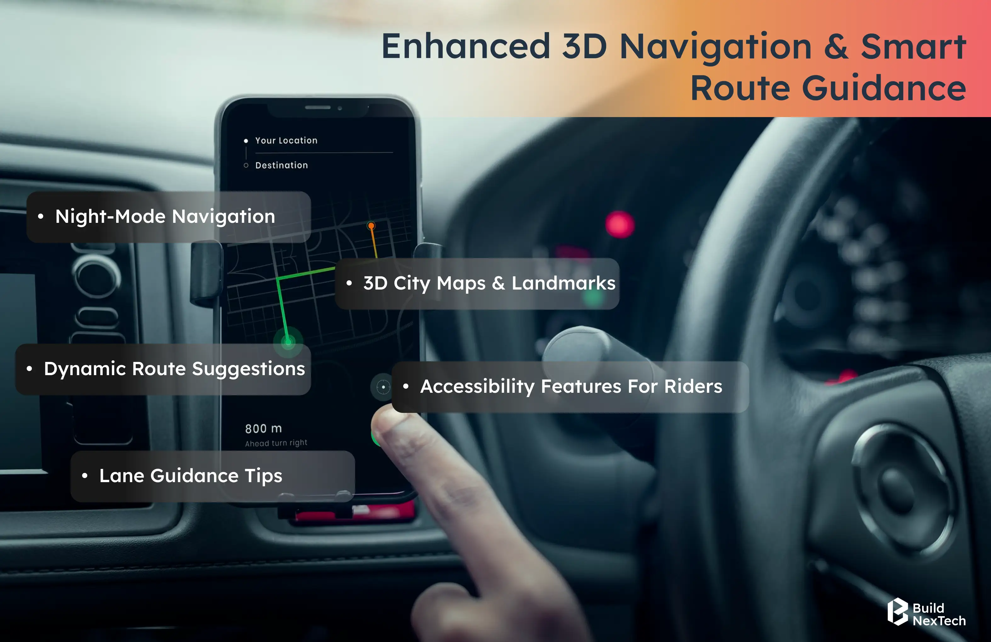
Event-driven architecture and event streams are behind these applications. They increase availability and sync among mobile applications (especially fleet management applications), navigation applications. Developers utilize event sourcing, SDKs, and APIs for real-time location intelligence, route optimisation, and location-based services to work seamlessly. There are offline maps, lane assist, spatial 3D driving sound, speed limit warnings, and points of interest views available for users on Android Auto, CarPlay, or mobile devices.
Mobility as a service includes technology advancements in driver payments, dockless scooters, electric vehicles, fare integration, and online booking services. Apps also offer carpooling, multimodal connections to local drivers, right-to-left language support, address verification, and reporting audits for emergency review for improved use of apps.
Key takeaways
- Real-time GPS and event-driven architecture deliver accurate ETAs and continuous tracking.
- Advanced mapping tools ensure precise navigation, traffic updates, and offline support.
- Event streams and microservices improve scalability, reliability, and system uptime.
- Dynamic route optimisation adapts instantly to traffic and road conditions.
- Modern mobility apps offer multimodal travel, accessibility features, and flexible booking options.
What Are Real-Time Apps Like Uber?
Real-time applications provide immediate updates and updates across mobility applications and ride-sharing applications, and facilitate continuous location tracking for every trip. Users depend on real-time GPS tracking to see where their vehicle is located in real time. A moving car icon with a precise estimated arrival time is displayed by the application. Event-driven architecture allows for rapid responses and solid real-time communication across devices.
Core Characteristics of Real-Time Applications
These applications handle incoming events with the least amount of latency. In doing so, they anchor stable tracking systems using event sourcing and live data streams, effectively maintaining high accuracy in mobile apps with concurrent usage loads.
- Real-time applications focus specifically on event stream processing for an immediate response time.
- They assure synchronisation across navigation app components.
- APIs and SDKs improve maps integration.
- Platforms are designed for limited downtime for active sessions.
- Digital audit trails are delivered for dispute resolution cases.
Why Real-Time Functionality Matters for On-Demand Services
On-demand platforms require a reliable event-driven architecture for ride management. Real-time location tracking creates trust with drivers and riders. Reliable estimated time of arrival estimates are important to the customer experience.
- With continuous updates, riders can confidently rely on planned routes.
- Real-time communication removes confusion when issues arise.
- When a traffic situation occurs, riders depend on the maps updating quickly.
- Event streams can reflect an updated status of a trip at any time.
- Third-party app integrations maintain consistent movement visibility.
How Real-Time Location Tracking Works in Uber-Like Apps
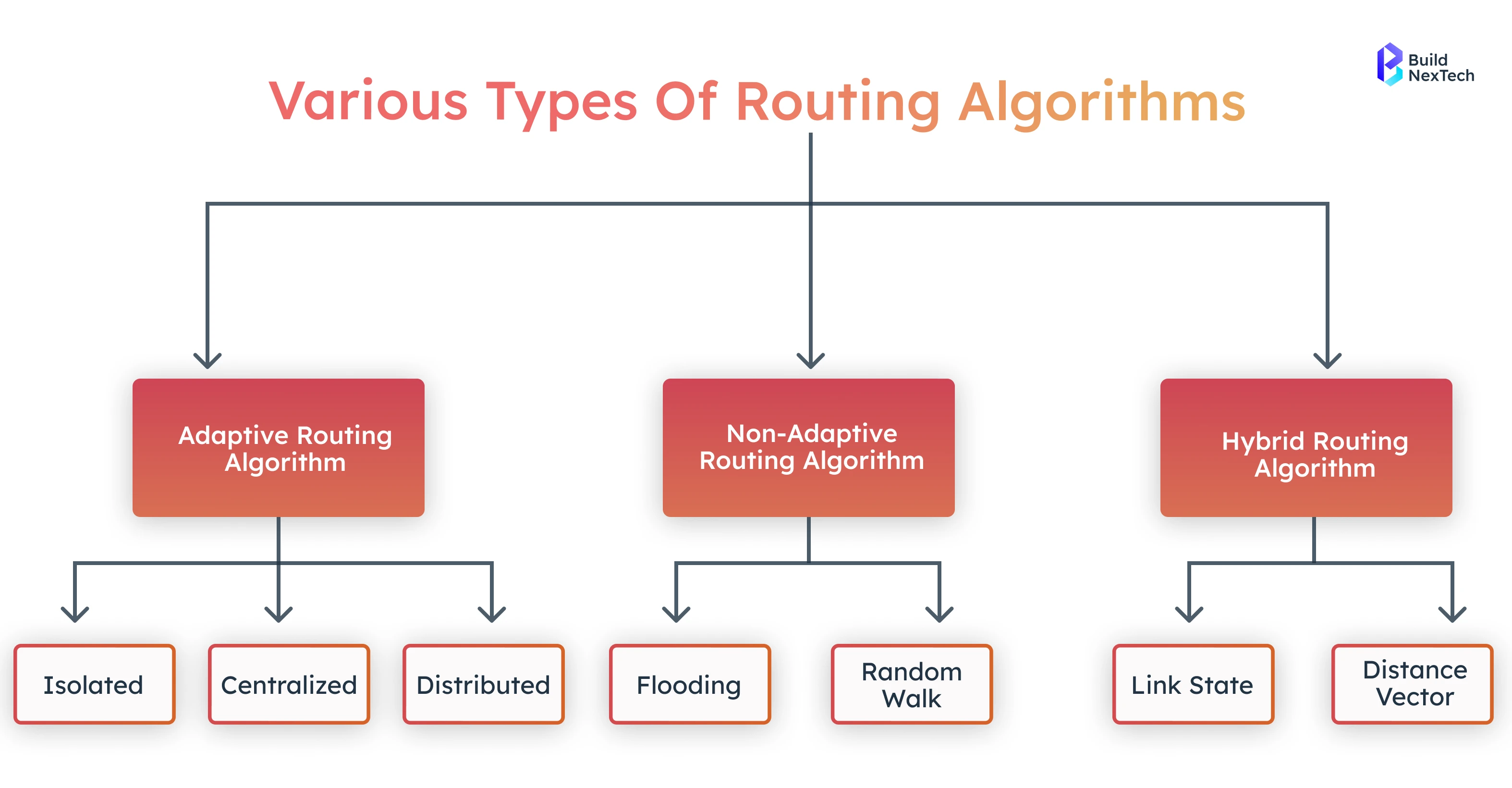
In tracking the location, GPS signals, device sensors, and mapping APIs are utilized. Applications then take that location data and overlay routing algorithms to identify movement. An event driven architecture will process each of those updates and reduce delays based on the original filename conditions.
API calls to the third parties support the navigation workflows and trip adjustments as requested. The ability to provide reliable location intelligence is important to prevent issues such as an unexpected change in price-trending conditions. Real-time location platforms automatically adjust fares to reflect a change in price anytime traffic, demand or routing causes the fare to change.
GPS, Sensors & Mapping Data Sources Explained
Location tracking systems utilize the accuracy of GPS and readings from your sensors. Mapping technologies enhance mobility application functionality by providing efficient route planning. Location-based services provide additional map context and information to give users a greater sense of navigation reliability.
- GPS signals serve to support the ride sharing apps core functionality.
- The use of your sensors can improve positioning accuracy in dense city environments.
- Mapping sources can highlight the availability of public transportation and provide up-to-the-minute traffic information to app users.
- Many of the mobile applications on the market are powered by the Google Maps API.
- Multimodal connections can also support travel options for riders.
Handling Continuous Geolocation Streams and Position Accuracy
Continuous location tracking needs strong event-driven processing. Systems use mathematical models to match driver movement with roads. Real-time ETA visibility depends on precise position updates.
- The Haversine formula computes distance accurately.
- Traffic during rush hour affects each estimated time of arrival.
- Routing algorithms adapt to on-road restrictions.
- Event streams maintain steady geolocation updates.
- Systems refine accuracy using movement history.
Mapping Technologies Behind Real-Time Mobility Apps
Mapping technologies assist mobility applications in traversing complicated road networks. Developers program APIs and SDKs, in order to do such things as displaying routes, apps can offer offline maps, and location sharing. Developers utilize these platforms to build iterations of mobility applications that can display speed limit notifications, rest areas, and points of interest.
Significant mapping solutions come from Google Maps, Mapbox, TomTom Maps, and Bing Maps. Uber Maps provides advanced mapping accuracy that improves routing performance and the real-time reliability of navigation. Mapping even takes responsibility to ensure navigation applications function effectively across diverse environmental contexts.
Mapping SDKs: Google Maps, Mapbox, OpenStreetMap
In contemporary application development, SDKs with dynamic mapping tools are essential to improve routing. The SDKs support integrated mobility as a service capabilities, alongside real-time tracking. Developers leverage SDKs so that visually clear maps can be presented with good accuracy.
- Google Maps has established reliability for real-time traffic tracking layers.
- Mapbox offers an appealing opportunity for strong customisation of generic mapping API's.
- OpenStreetMap is a source of location data that is built from community submissions.
- HERE WeGo is an example of a mapping API with an impressive offline map capability.
- Geo-Location Platform map services make it simple to develop an event driven architecture.
Real-Time ETA Calculation & Route Optimisation
Real time route optimisation improves travel efficiency for riders. Dynamic ETA calculations adjust to changing conditions. Fleet management app systems use these tools to enhance driver experience.
- Algorithms shift routes during unexpected delays.
- Systems predict traffic updates with high accuracy.
- Real-time ETA visibility supports rider confidence.
- Apps use navigation API data for better planning.
- Fleet tools monitor driver throughput for improvements.
Event Streams & Event-Driven Architecture
Event streams allow for asynchronous data transfer between mobility apps and ride-sharing apps. They enable real-time engagement between the driver and rider across each trip. With an event-driven architecture, downtime is significantly reduced when events are distributed across services that are synchronised. Event stream tools give developers the ability to visualise movement with precision. Event streams also help enable digital audit trails to resolve disputes and maintain historical records. Mobility platforms use many different sources of big data to inform routing, forecasting and real-time decision-making.

How Event Streams Power Real-Time Data Flow
Event streams record activities by drivers, riders and server events for each task, in some situations occurring all at once, and allow datastreams to flow endlessly across the application layers in the navigation app. The event streams will hold event sourcing as well for accurate tracking.
- Events reflect each movement recorded during rides.
- Streams ensure smooth synchronisation across mobile apps.
- Systems use event sourcing for a complete operational history.
- Real-time route optimisation depends on clean event flow.
- Trip-planning app features rely on consistent event updates.
Implementing Kafka, Redis Streams, or MQTT
Different technologies handle event workloads across map solutions. Kafka manages heavy throughput and complex event sourcing. Redis Streams supports lightweight communication, while MQTT suits smaller devices.
- Kafka manages large-scale event distribution.
- Redis Streams supports quick mobility app updates.
- MQTT powers electric scooter and dockless scooters tracking.
- These tools enhance fleet management app operations.
- Event tools support retail operations and field services.
Backend Architecture for Uber-Like Real-Time Apps
A microservices architecture handles routing algorithms, online payments, etc., on the backend to provide dependable real-time location tracking for a mobile application. Event driven architecture microservices provide scalability, reliability, and operational efficiency for real-time operations without downtime. This architecture increases operational stability and system stability. Developers provided app development patterns to utilize API calls and use navigation API logic. Microservices also help to orchestrate ride services and manage fare integration flows.
Microservices for Scalability and Fault Tolerance
Microservices split ride-sharing apps into manageable parts. They isolate failures and support long-term performance. This design helps developers maintain stable location intelligence.
- Microservices scale easily during peak demand.
- They improve driver payouts through dedicated services.
- Systems track assets folder items efficiently.
- Backend units handle on-road restrictions independently.
- They integrate cleanly with Google Admin Console tools.
Key Features of Real-Time Ride-Sharing Apps
Real-time ride-sharing applications combine essential mobility and navigation features to deliver a seamless trip experience for users. These apps support location sharing, GPS tracking, online payments, and access to local drivers and ride-share options. Additionally, services such as Able Ride web booking and browser-based scheduling improve accessibility for users who may not always rely on mobile apps. Real-time updates tie together every stage of the journey, enhancing the overall concept of mobility as a service. With tools for accurate location tracking, multilingual support, and continuous communication, these platforms ensure smooth, reliable, and globally adaptable ride experiences.
Key Functional Features
- Live GPS tracker tools show movement precisely in real time.
- Continuous real-time tracking enhances confidence and trust for riders.
- APIs support accurate address verification across platforms.
- Navigation app features include lane assist tools for safer routing.
- Apps support right-to-left languages, improving global accessibility.
- Web-booking services like Able Ride expand access for users without mobile apps.
Conclusion — Future of Real-Time Location Technologies
The future of spatial and mobility applications and real-time location tracking services will be built on event driven architectures, event streams that minimise downtime and maximise synchronization. Platforms already wrapped around Google Maps API, HERE WeGo, TomTom Maps, Bing Maps, and generic mapping APIs will support real time GPS tracking, real-time route optimization and location intelligence.
Offline maps, lane assist, spatial 3D sound, driver payouts, dockless scooters, electric vehicles, fare integration, web booking, local driver per mile, rideshare or carpool, support for right to left languages, digital audit trails, address verification, traffic updates, rest areas to eat or rest, real time alerts on public transit options will enhance customer experiences and navigation apps performance.
At Buildnextech, we deliver trusted software development services, expert mobile app development, scalable web development services, tailored custom software development, and innovative AI development services for businesses worldwide.
People Also Ask

1. What technologies enable live mapping and GPS updates in a mobile app?
Live mapping is the combination of GPS, device sensors, and mapping SDKs such as Google Maps, HERE WeGo, TomTom, and Bing Maps. APIs and event streams enable users to continue tracking location in real time and optimise their chosen route.
2. Why are WebSockets necessary for real time communication for on-demand services?
A WebSocket creates a persistent two-way channel between a client and a server. It offers instant updates with less latency and increased real time GPS tracking visibility for drivers and riders.
3. What does event-driven architecture do to enhance a real-time app's capability?
An event-driven architecture will process incoming data as events, which promotes lower latency. It promotes scalability, reduces downtime, and keeps fleet management and navigation apps synchronised.
4. What are the critical features needed in an Uber-like real-time application?
The critical features are real-time GPS tracking, estimated time of arrival, route optimisation, driver payouts, fare integration, offline maps, carpool options, and multimodal connections.
5. What are some challenges related to real-time tracking?
Challenges include when traffic changes, GPS errors, network downtime, data synchronisation issues, and continuously tracking location across multiple devices.


.webp)
.webp)
.webp)